


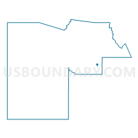
FREESTONE Voting District, Maricopa County, Arizona
About
Outline

Summary
| Unique Area Identifier | 523948 |
| Name | FREESTONE Voting District |
| County | Maricopa County |
| State | Arizona |
| Area (square miles) | 2.04 |
| Land Area (square miles) | 2.03 |
| Water Area (square miles) | 0.00 |
| % of Land Area | 99.91 |
| % of Water Area | 0.09 |
| Latitude of the Internal Point | 33.35597170 |
| Longtitude of the Internal Point | -111.67761340 |
Maps


Graphs
Select a template below for downloading or customizing gragh for FREESTONE Voting District, Maricopa County, Arizona


Neighbors
Neighoring Voting District (by Name) Neighboring Voting District on the Map
- EASTRIDGE Voting District, Maricopa County, AZ
- HIGHLAND Voting District, Maricopa County, AZ
- MORRISON RANCH Voting District, Maricopa County, AZ
- SUPERSTITION Voting District, Maricopa County, AZ
- TOWNE MEADOWS Voting District, Maricopa County, AZ
- VILLAGE Voting District, Maricopa County, AZ
- WILLIAMS FIELD Voting District, Maricopa County, AZ
Top 10 Neighboring County Subdivision (by Population) Neighboring County Subdivision on the Map
Top 10 Neighboring Place (by Population) Neighboring Place on the Map
Top 10 Neighboring Unified School District (by Population) Neighboring Unified School District on the Map
- Gilbert Unified District, AZ (184,433)
- Higley Unified District, AZ (64,704)
- Queen Creek Unified District, AZ (26,329)
Top 10 Neighboring State Legislative District Lower Chamber (by Population) Neighboring State Legislative District Lower Chamber on the Map
Top 10 Neighboring State Legislative District Upper Chamber (by Population) Neighboring State Legislative District Upper Chamber on the Map
Top 10 Neighboring 111th Congressional District (by Population) Neighboring 111th Congressional District on the Map
Top 10 Neighboring Census Tract (by Population) Neighboring Census Tract on the Map
- Census Tract 4226.41, Maricopa County, AZ (6,346)
- Census Tract 4226.17, Maricopa County, AZ (5,866)
- Census Tract 4226.23, Maricopa County, AZ (4,812)
- Census Tract 4226.22, Maricopa County, AZ (4,237)
- Census Tract 4226.18, Maricopa County, AZ (2,954)
- Census Tract 8176, Maricopa County, AZ (998)